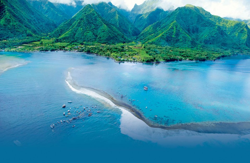
 TEAHUPO'O, Tahiti (Sunday, August 17, 2014): The Billabong Pro Tahiti, Stop No. 7 of 11 on the 2014 Samsung Galaxy ASP World Championship Tour, has been placed on standby this morning with a significant swell projected to fill in overnight for a probable commencement in the morning. "Slight increase in surf this morning but we're anticipating the real pulse to begin filling in this afternoon and through tomorrow," Kieren Perrow, ASP Commissioner, said. "As such, we've placed the event on standby this morning and expect to commence competition tomorrow. With the swell picking up this afternoon, it will be a great opportunity for the surfers to get another warm-up in before it gets serious tomorrow." Surfline, official surf forecasters for the Billabong Pro Tahiti, are confidently predicting excellent conditions in the days ahead and have called for: The surf will be on the rise this afternoon, although the bulk of the new swell will arrive on Monday with solid surf. Tuesday will see a temporary easing trend, although will remain good size. Another strong SW swell is on track forWednesday afternoon/Thursday. We're tracking more swells for FridayPM/Saturday and Monday/Tuesday. Event organizers will reconvene at 7.30 a.m. on Monday, August 18 to make the next call. Billabong Pro Tahiti Round 1 Match-Ups: Heat 1: Kelly Slater (USA), Sebastian Zietz (HAW), Glenn Hall (IRL) Heat 2: Michel Bourez (PYF), Matt Wilkinson (AUS), Raoni Monteiro (BRA) Heat 3: Taj Burrow (AUS), Adam Melling (AUS), Brett Simpson (USA) Heat 4: Mick Fanning (AUS), Alejo Muniz (BRA), Mitch Coleborn (AUS) Heat 5: Joel Parkinson (AUS), Adrian Buchan (AUS), Nathan Hedge (AUS) Heat 6: Gabriel Medina (BRA), Mitch Crews (AUS), Taumata Puhetini (PYF) Heat 7: Adriano De Souza (BRA), Miguel Pupo (BRA), Dion Atkinson (AUS) Heat 8: Nat Young (USA), C.J. Hobgood (USA), Tiago Pires (PRT) Heat 9: Kolohe Andino (USA), Fredrick Patacchia (HAW), Aritz Aranburu (ESP) Heat 10: Josh Kerr (AUS), Julian Wilson (AUS), Jadson Andre (BRA) Heat 11: Owen Wright (AUS), Bede Durbidge (AUS), Travis Logie (ZAF) Heat 12: Jordy Smith (ZAF), John John Florence (HAW), Kai Otton (AUS) Images from the event will be available from Getty Images. In addition a small number of hand-out images, as well as daily news feeds, will be made available for editorial use via our email distribution lists. Please contact[email protected] (images) and [email protected] (news feeds) to be added to the lists. The seventh stop on the 2014 Samsung Galaxy ASP World Championship Tour, the Billabong Pro Tahiti, is webcast LIVE via www.aspworldtour.com. 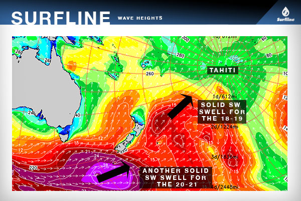 BRIEF OVERVIEW: Solid SW swell will build in on Monday, peak through the afternoon and offer very strong surf all day. Weak ENE trades early will shift to light/variable in the afternoon. Tuesday will see easing swell/surf as S wind increases in the afternoon (after light AM wind). Another strong SW swell builds Wednesday afternoon and continues Thursday as wind shifts from SE (Wed) to ESE (Thur). More SW swell is due for the last 3-4 days of the waiting period, although we may see unfavorable wind develop over the weekend.
MONDAY 18th: Very solid SW swell fills in further and peaks through the afternoon SURF: 10-15’+ faces, largest sets in the 18’+ range on the face. WIND: Light ENE/NE wind in the morning under 8kts. More light/variable wind developing through the afternoon with periods of weak onshore flow possible. TUESDAY 19th: Decreasing, but still solid, SW swell SURF: Down from Monday but still solid 8-12’+ faces and larger sets possible in the morning. WIND: Light/variable through the first half of the day with S wind potentially building in the later afternoon. Stay tuned. WEDNESDAY 20th: Old SW swell in the morning; New SW swell builds through the afternoon and is strongest late; storm dependent, stay tuned SURF: Slower start but building back to 8-12’+ faces in the afternoon, with larger sets pushing up to 15’+ faces possible by sundown. Stay tuned, this is dependent on storm behavior in the next couple days. WIND: Increased SSE shifting SE wind 9-16kts+ (strongest in the afternoon). Stay tuned. THURSDAY 21st: Solid SW swell is strongest in the AM before slowly easing PM SURF: 8-12’+ faces, larger sets in the 15’ range on the face. WIND: ESE wind 9-14kts. FRIDAY 22nd: Fading SW swell; new swell may start to build late SURF: 6-10’ faces. WIND: Light to moderate E trades. Long Range Surf Outlook The swell that is slowly starting to pick up this afternoon will fill in further on Monday and peaks through the afternoon. Surf will be solid all day but as the swell peaks look for double to triple overhead range (10-15-18’ faces) surf and some larger max sets not out of the question. Tuesday will see decreasing, but still strong, surf in the well overhead to double overhead+ range with even a few larger sets lingering in the morning. The next swell on the radar is for Wednesday afternoon and into Thursday, from a recent fetch to the south and east of New Zealand. We’ve had a couple of satellite passes showing 30-35’ seas within the storm and we are anticipating another very strong swell to build Wednesday afternoon and show strongest at the end of the day Wednesday and into Thursday. This swell looks a touch under Monday’s swell but still double overhead+ with the bigger sets pushing 15’+ faces. Stay tuned, we’ll track this swell as is moves toward Tahiti over the next few days. Beyond that, forecast charts indicate that the southwest Pacific will stay very active and we should see another series of strong SW swells for the last few days of the waiting period. At this point we have new SW swells on the radar for Fri/Sat the 22nd-23rd and then again for Sunday afternoon through Tuesday the 24th-26th. The Fri PM/Sat swell looks several notches smaller than the swells earlier in the week, but will still provide overleaf waves if the storm behaves as forecast. The Sun-Tue swells looks larger and could be in a similar league to the swells we’ll see the next few days. Wind: We’ll see a wind shift over the next couple days as a result of low pressure sinking to the southeast of French Polynesia. Weak ENE trades Monday morning will give way to light/variable flow at Teahupoo in the afternoon (and northerly wind elsewhere around the island). Periods of weak onshore flow are possible through the afternoon. Tuesday will again start with very light and variable wind, with wind trending from the S in the afternoon and especially evening hours. Stronger SSE shifting SE wind develops through Wednesday as high pressure builds in from the southwest. Light to moderate ESE trades prevail Thursday and into Friday. The latest chart/model info indicates less favorable wind could develop over the weekend of the 23rd-24th. Stay tuned.
0 Comments
Leave a Reply. |


Archives
August 2021
|
