Throw away the iPhone. Who needs internet forecasts to predict when surfs on the way? All you gotto do is check the loo, bru! Next time the wind is pomping as a cold front is smashing us, go check the water level in your toilet bowl. You'll notice it will have dropped a bit lower than normal. Say hello to the "Toilet barometer". So every morning instead of logging onto your phone to check the forecast, just pop your head over the loo and see what the water level's doing. Gone down? Good - low pressure system is around and there's a chance of waves. It sounds kinda crazy, but it actually does work. Learnt it way back in the day from Seals legend and weather guru extraordinaire, Eric Stedman. Here's the low down on the weird loo levels. Basically the water in your loo is in an s-shaped combination of curved tubes. If the far side of the tube develops under-pressure, some of the water will be pulled over into the far side, and water level in your toilet bowl will sink. Where your loo pipe comes out the wall it has a lil chimney pipe coming off of it vertically with a small vent at the top (which gets rid of the pong). 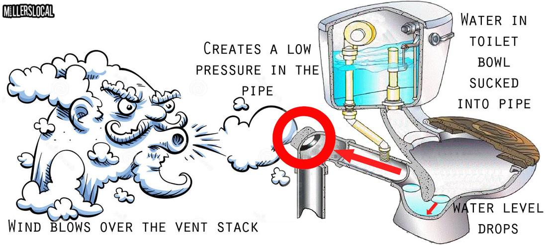
On windy days, this chimney can act like a pump. The wind blowing over it creates a low pressure in the pipe, which then sucks some water out of the toilet and into the pipe. Which is why you see the loo bowl level drop. There's actually a scientific principle that explains the scenario: Bernoulli’s principle. It's all about fluid dynamics. Because fluids like air and water tend to move towards area of decreased pressure, lower air pressure results in a suctioning effect throughout the plumbing system, which ultimately lowers the water level in your toilet bowl as the winds start to howl as a cold front moves through. Conversely, calmer weather conditions result in increased air pressure in the toilet and higher water levels as a result. So go check ya loo during the next cold front. Betcha you'll notice the water level will have dropped a bit. 
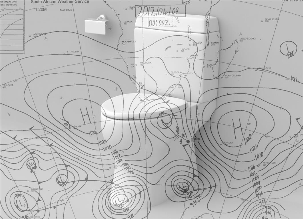
Ou's checked the loo, and look what they found!
Yrrrr, ou's are gonna be losing their marbles soon if this flat spell lasts any longer. This has been a pretty horrendous run of zero swell and onshores. I decided to go crunch some numbers to see just how bad "bad" actually is. And the outcome? Bad. Very bad!! I checked out the weather stats for October and November, and they make rather kak reading. Basically each month had only 6 surfable days (we're talking the bay here - so not wildside or seals etc). By "surfable" I mean when you have the combination of a SW wind and a swell of over 2m, with a swell period of over 11 seconds. Now that is actually hardly decent surf in anyone's books, but that's how low I had to set the benchmark in order to come up with some workable stats!! 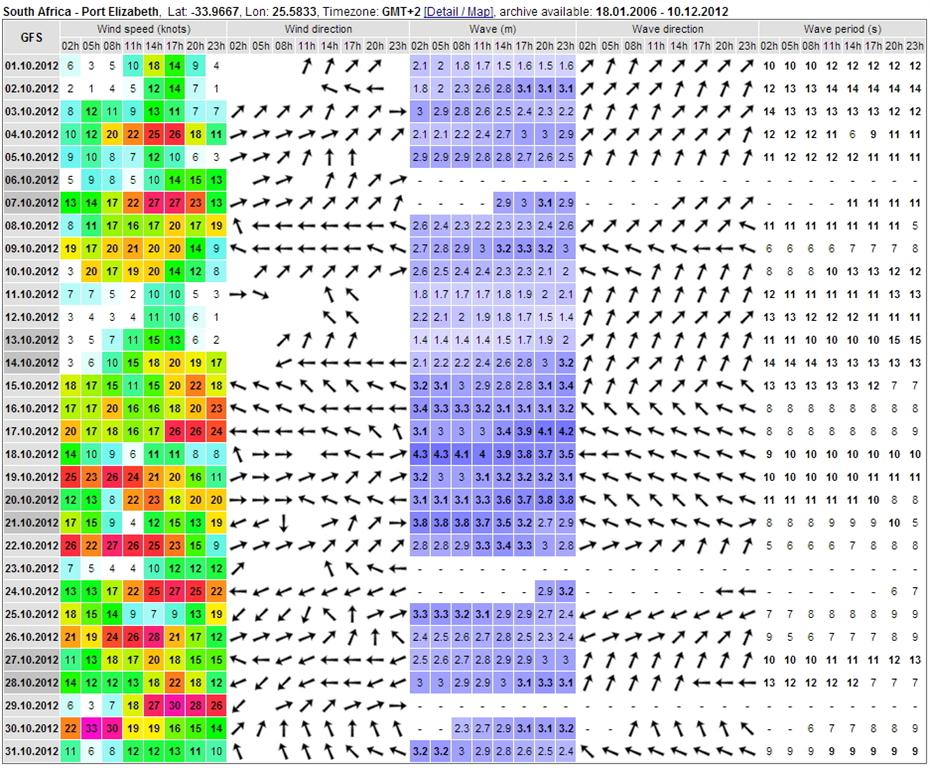 October saw only 2 days that had swell periods of over 14 seconds - which is generally the sort of period you're looking for in order to get surf with some punch. Of the 8 days that had both the offshore and a bit of swell coinciding - 4 had such hectic wind that it was hardly worth the effort. 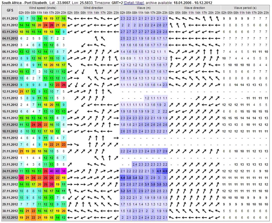 November didn't get any better - 6 surfable days of which 4 the wind was pomping. Only 2 days with a decent swell period, and one of those was onshore! Looking back at the Photo Galleries for 2011 and 2010 on the site - there were 14 up for Oct/Nov last year, and 16 for Oct/Nov 2010. This year? Seven. Eish.
So yah, a sad story all in all. 60 days and only 12 surfable by "ideal" standards. If you're into onshore bowls then you were probably managed to rack up more than 12 days surfing, altho given the lack of swell it would've had to be small onshore bowls! Summer surf in the bay can really test your patience....so if you're wanting to get wet regularly you're going to have to fill up the petrol tank and head outside the bay. Plenty of nooks and crannies out there if you're prepared to go looking. Just watch out for the pearlies and the great whites! Summer see's the juveniles pull in to the exposed beaches to chow, so keep your eye's peeled! You aren't on the menu, but it doesn't hurt to keep a lookout. Oh, and just to REALLY make your day - looks like this run of east wind is set to continue. Just a quick swing to south on Saturday and Monday, but otherwise east, east, east. Ask Santa for a West!!!! When I worked with Surfline in creating their Pipe Surf report, we ended up having to link in to a private weather station out in Lovemore Heights, cos for some strange reason the data feed from the PE airport wasn't in the format that Surfline could import.
This meant that the winds on the surf report were sometimes a bit out, as what happens that end of PE can be different to what's going on at the beach. Lucky for us, a new weather station at NMMU has just come on line, so the kind peeps at Surfline have updated the surf report so that it pulls data from here instead. Which is great, cos now it means the winds you see on the Pipe Surf Report should be pretty much spot on accurate as to what's happening at Pipe right then, when you look at the report. Remember, the Pipe report is updated automatically during the day to incorporate Surfline's predicted swell for that time of the day (and they're pretty flipping accurate), and the live weather from the NMMU station. So what you see on the report is actually what should be happening at Pipe right then. Nice to check back during the day to see how conditions are changing, or if you're wanting to keep an eye on the wind to see when the west pulls through. Winds are updated every 30min or so. So there you have it peeps, go check out the new and improved Pipe Surf Report under the Forecasts tab on the main menu. Now if only it wouldn't say stuff like 0-1ft (like it does today), then we'd all be a lot happier.... |
 AuthorMillerslocal Archives
July 2021
|
 RSS Feed